
Over some years, I have considered my theories on the development of thermals and streets, as the two blend together, and they consistently appear to be proved correct. Most of the ideas are from my personal observations, but stem from a concept mentioned in Wallington’s Weather for Glider Pilots. The use of the lee side of bush as a thermal source works from the very first thought in the morning to the end of the day.
By James Cooper
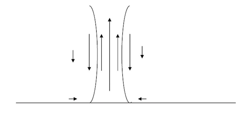
We should be aware of the basic structure of a thermal, once fully developed. Note that in the case drawn, it is a classic thermal with no wind shear, and assumes a nice column length. At the bottom, the thermal is dragging in surrounding air. Remember this when you are low, or you will get dragged into the core. It rises but, due to the friction between the rising column and the surrounding air, the core will rise faster than its edge. As the rising air has to be replaced, a down draft will develop adjacent to the rising air.
The friction between the sinking and rising air will develop turbulence that is noticeable as you enter the thermal from the side. As the thermal reaches the top, it is spread out by the inversion and will try to push you out. If you must continually try to recentre at the top, this could be why, and it may be time to go. You should be able to see from the diagram why the core is so much stronger and therefore why it is necessary to make quite a tight turn.
When considering a bubble rising you will be aware that the core of the bubble will be going up at a higher rate than the edge of the bubble. Therefore, the rate of ascent of the whole bubble will in fact be lower than the core itself. Bearing this in mind, it may in fact be possible to out-climb the bubble. This could indicate why some climbs start well and get a little rough as you climb through the bubble. The climb rate then drops off but becomes smooth as you reach the top of the bubble but continue to climb on the top of it.
Thermals bend with the wind, or is it against?
As we have seen from the descriptions above, the thermal will form a vertical column. Just look at a willy willy and you will see its vertical tendency. Thermals do not bend into wind or down wind. There are some cases where kinks may occur in a thermal.
They may also lean as they exit the thermal source on the basis that the air leaving the ground is still and the upper air will be stronger. The rising air will need to accelerate and, having mass, this may take time.
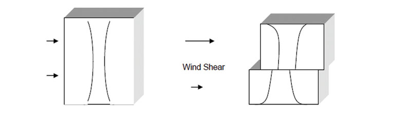
Wind Shear
When considering what happens to a thermal column you need to think of it in a box of air that is travelling downwind with it. The bubble will be rising vertically in the box and so form a vertical column, while the whole box is drifting downwind. The problem arises when the top of the box is moving downwind at a different speed, compared to the bottom.
We can see in the figure on the right that the wind shear will move the upper column downwind.
Shift into wind or downwind
When you have lost the core of the thermal, you will have to recentre on the assumption that you have not lost it due to inaccurate flying. The general comment is move into wind. This is good when you have reached the top of the thermal, or fallen out of the bottom. Move into wind to find the original thermal source. However, if there is a wind shear, wind usually gains strength with height, and it will be necessary to move downwind, i.e. with the shear. You can see from the diagram that if you are at the top of the bottom half of the thermal, to move back into the core you need to move with the shear to get into the bottom of the top half of the thermal. On this basis it makes sense to examine the weather report in the morning.
Cumulus
If we are lucky enough to have cumulus forming, cross country speeds will be increased dramatically. You can see the thermals and will be able to use them like stepping-stones to fly like across the sky from one to the other. With careful observation you can see the core as you approach. In addition, the thermal strength is generally stronger under a cu so that for the same thermal height in the blue, normally 1kt strength per 1,000ft height band, I have also heard 1kt per 1,000ft minus 1. This makes a little more sense.
Why does a cumulus increase the lift?
l When you boil a kettle you have to put in energy to convert the water to water vapour. Knowing Newton’s law - for every reaction there is an equal and opposite reaction - if you convert water vapour to liquid water, you get energy back.
l Air can only hold so much water vapour. The cooler it is, the less it can hold.
As the thermal rises, cooling at 3° per 1,000ft, it will eventually reach a height where it has cooled to the point at which it can hold no more water vapour. This is the dew point. The water condenses and, as we have seen above, we will get some heat input into the thermal. There will now be an added boost to the thermal. Once the cloud has developed sufficiently, it will actually begin to suck air in. If you can keep in contact with the cu’s, there is a great advantage.
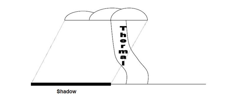
When flying on a cumulus day it is worth noting how it will affect the thermal sources. If the sun is high in the sky, in effect, it produces shadows directly under the cu. This will cut off the thermal source, so the thermal will not last for long. Well, this is what we may think at first. On the basis that the sun is on the ground adjacent to the shadow producing the hot layer of air, that will now become thicker than the air above the ground in the shadow.
Another thermal will rise, but to the side of the cloud along the shadow line. It will tend to rise vertically and then shear to one side so as to be directly under the sucking Cu. If there is any wind, we can assume that the thermal column will not be upwind of the cu as it will already have consumed that air. If the sun is other than directly overhead, there will be a tendency for the thermal source to be on the sunny side of the cu as this gives the least path of resistance to the rising thermal.
Wave
Wave is a phenomenon that we get more often than we recognise, although sometimes we recognise it when it is not actually there. On the flat lands where we fly, the wave is generated either by wind shear or by a frontal system to the west. The wave can be visible by producing wave bars in the form of lenticular or cumulus with smooth tops. The effect of the upper level wave will affect the thermal activity right to the ground. The secret is to recognise it and act accordingly.
When the wave is on the up stroke, there will be a tendency for the wave to pull thermals from the surface. They will break away smoothly and tend to achieve higher altitudes than we would normally expect the day to achieve - that is, under the cloud and towards its windward edge, that being the upper wind.
When the wave is on its down stroke, it will tend to depress the thermals. If the thermal rises due to the reasons mentioned previously it would in turn be depressed by the upper wave. On that basis you will tend to get large areas of air trying to gain height but in turn being depressed - in other words, areas of rough thermals going nowhere. The danger is assuming the thermals are no good and pushing on when all you are going to run into is further subsiding air. The wave length may be many many kilometres.
Remember that it is unwise to go cross wind in the down part of the wave. Better to push into or down wind to find the best part of the wave before going across.
Rogue Thermals
We have a term called rogue thermals, which are considerably stronger, smoother and go higher than others found on a given day. The problem is recognising them and being aware that the day has not actually improved. The tendency of the glider pilot having taken a 10ktclimb, for example, is to push on hard, leaving the 6kts he would had previously taken behind, until he starts calling Kilo Uniform and landing out.
I do not know the reason for these rogue thermals forming and would dearly like to know how to track them down. Don’t confuse them with the sea breeze front, which can have a similar effect, but in addition has a strong wind and no thermals behind it!
jamescooper.com.au


