
Track line on map from Tocumwal to Mt Arthur. First aiming point is Berrigan township. From there, the bottom end of Lake Urana should be visible on a normal day. There is a straight road from Urana to Boree Creek. There is also a wheat silo on track on the Sturt Highway southeast of Narrandera. These are all good head out of the cockpit navigational checkpoints.
Cross Country Planning
By Matthew Cameron
All cross-country flying is an act of faith. It is claimed with some justification that such flying is the apex of the gliding art. Certainly it encompasses many flying and planning skills in the one package.
Without a doubt the need to thermal efficiently is the backbone of the whole flight, irrespective of the location. Selection of the day is also important as the meterological conditions will dictate the distance possible, and good terrain is necessary for safety.
It was one of those slow days, in the low 30s, some fluffy white cumulus scattered around and, for some odd reason, not much gliding. Eventually one of the low-time pilots approached the CFI and suggested that he attempt a cross-country flight of some 100km. The CFI agreed and suggested I occupy the back seat of the glider as the only other instructor available.
Doomed from the Start
As we readied ourselves for take-off, I thought that the pilot was pushing it a bit – as far as I knew, there had been no planning as such. Airborne, we dropped the tug at the first thermal, which in my opinion was not all that strong, and our hero was back on the ground seven minutes later. A cross-country flight that was doomed from the start.
The is an old adage that says ‘Proper Preparation Prevents Poor Performance’, the 5 Ps. The writer would suggest that a large percentage of failed cross-country flights are a result of less than proper planning.
If you are going to fly cross-country, certain aspects of planning should be considered on every flight, even flights of short duration. Personal hydration is a familiar one. Continual hydration is very important on hot days. Do you carry enough carry enough extra water to allow for possible out landing? I have had two occurrences in relation to hydration, neither nice, and thankfully I was on the ground on both occasions.
On hot days when flying a cross-country, drink plenty of liquid with breakfast, and when driving to the airport and when getting ready for flight, force yourself to drink more. Get into the habit of constantly sipping in flight. Flying high, where the outside air temperature is lower, also helps.
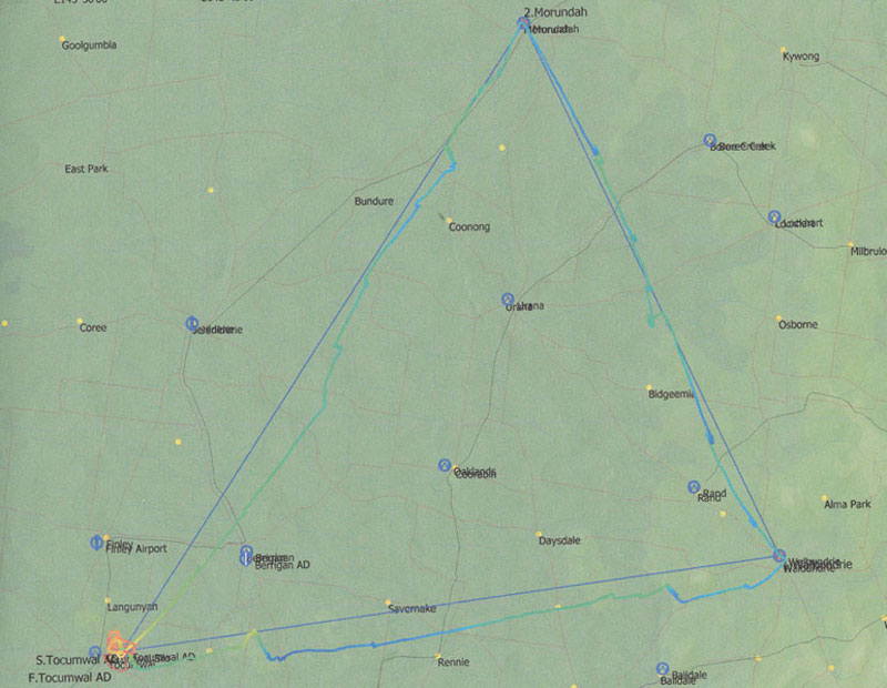
Cross-country over a favoured triangular course. Tocumwal-Walbundrie-Morundah-Tocumwal. Good gliding terrain and safe
Common Pitfalls, Simple Remedies
One of the most basic planning requirements is a knowledge of glider performance. When properly flown in still air conditions, just how far will your glider travel from, say, 10,000ft? It may well be the difference of getting to a suitable landing area or out-landing in an unsuitable one. What is the answer to the same question if you are either 10kts below or above that best speed?
The other item that has become obvious to me is the general lack of navigational knowledge within the gliding community. I am aware that gliding imposes different requirements on pilots and sometimes you have to divert off your planned track to obtain lift to remain aloft.
But techniques that light aircraft pilots use often be put to a glider pilot’s advantage. To claim that such techniques are not applicable to gliders is simply rubbish. You would probably add that the speed of a glider varies greatly, having to slow down to access lift. While this is true, you can use average speeds to obtain some useful data – mental arithmetic is a great asset in the air.
It is important that you identify before take-off those items that are either on track or just slightly to one side that will allow you to navigate without constantly putting your head in the cockpit. Long straight roads, distant hills, lakes, swamps, rivers etc are all useful and useable. It may be advisable to change your destination to take advantage of such items.
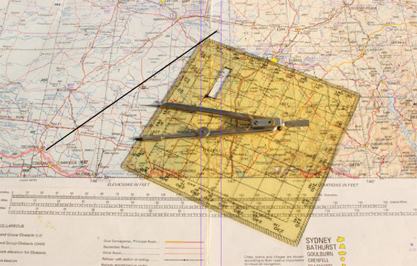
Map and Wind Reading
One experienced CFI claimed that most cross-country flying only involved map reading. If he is correct, how good are your map reading skills? I hasten to add that I totally disagree with his statement. Furthermore, most cross-county pilots fail to recognise that being blown downwind of your preferred track costs you a lot of time to beat upwind due to the reduced groundspeed. It is preferable not to go there in the first place.
You should have enough knowledge to be able to use the forecast winds to calculate the wind drift at an average gliding speed for any leg of a proposed cross- country route, plus whether the same wind is giving you a head or tailwind component. Be aware that slowing down for a good thermal will cause you to drift downwind. You do not want to spend the last long leg home working continuously into a strong headwind in conditions of probable weakening lift. The chances of out landing are much higher.
In addition to the wind and its velocity you should also be able to calculate the average true airspeed of the glider. None of this is rocket science and any student power pilot should be able to assist you. It’s all very basic stuff. However, from observation, few pilots can carry out the procedure, and many are simply not interested.
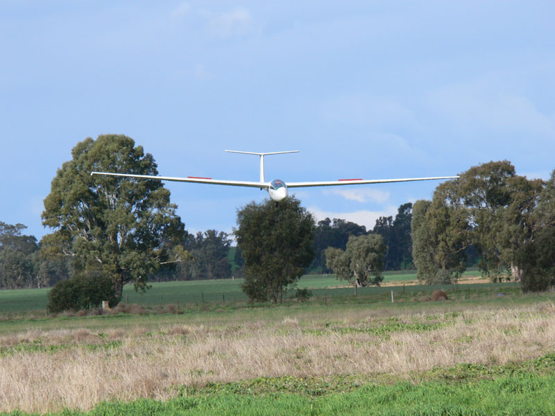
Successful return from a dual cross-country.
Where Are We Going?
The very first planning decision is simply where are you planning to fly to. Is it to be an out and return, a triangle or other multiple legs? You may be forced to fly multiple legs to remain within the best terrain conditions to achieve the maximum lift. Your planning must be flexible enough to change destinations on the day. The alternative is to have several plans to different destinations and select the most favourable depending on the weather conditions.
It goes without saying that the status of the terrain over which you are going to fly is critical if you are to succeed. It might have the best cut crop paddocks in the state but if they are wet or still hold moisture from some weeks before, they will be less than useful to you. In addition, since a long flight is going to take you out of your comfort zone, you must be prepared.
Allow electronics to assist in the planning. Google Earth allows you to draw a track line on the surface of the earth and inspect the terrain beneath at low altitudes. In addition you can pick out major stand-out navigational features en-route that allow you to keep your head outside the cockpit where it belongs instead of searching for features on a map. Such large features are visible at some distance depending on your altitude. It is vital that you choose the type of terrain over which you are going to fly with care and thought.
Weather Watching
Irrespective of where you choose to fly, whether you succeed on any particular day depends entirely on the weather conditions you are presented with but, if you have planned properly that will be evident at least 48 hours before you flight. For a long cross-country flight, I suggest that you should start accessing the weather, looking for trends at least seven days before take-off. The last 48 hours are critical.
Particularly watch out for encroaching cirrus later in the day of the flight. It will kill lift and perhaps leave you far from home without any friendly lift! If the day is considered marginal, perhaps the decision should be to await better conditions on another day. Depending on exactly what time you are prepared to take-off, you must be aware that initial climbs are likely to be weak and gain strength as the day progresses. It may pay to take a higher than normal tow before you cross the start line, allowing you to settle down before seeking the first thermal.
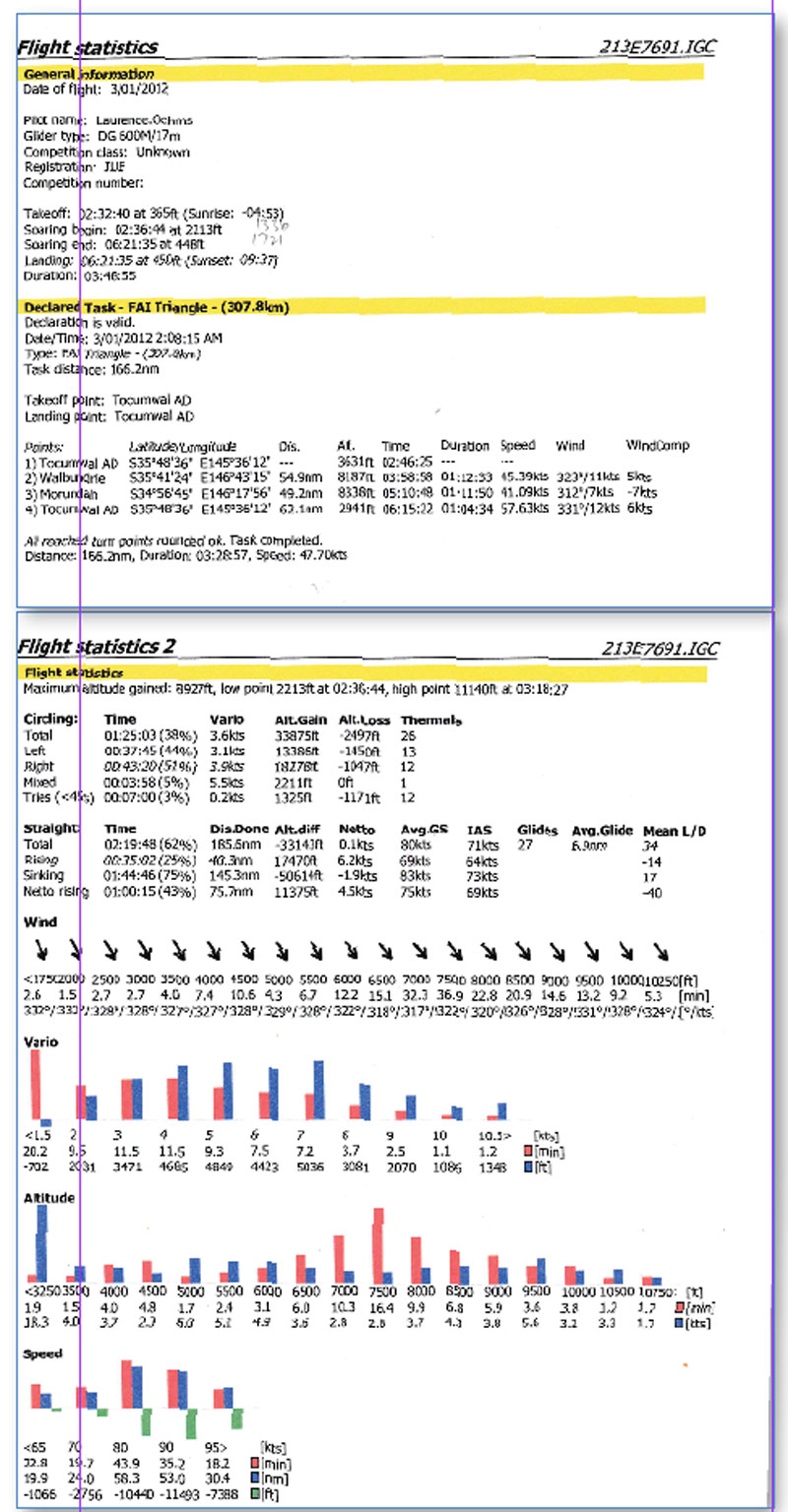
Analysis of the recent flight provides much information and data.
Trusting Instruments
In this electronic age, some consider carrying paper maps in the cockpit to be a relic of the stone age. Perhaps, but I have a different point of view. Such a map, marked with the appropriate track you propose to fly, is invaluable, particularly if the electronics fail. I have had such an experience myself.
When you get into trouble, what will save your bacon is a good grasp of the basics, whether they be navigation or flying skills. If faced with a possible outlanding, my only advice is to make the decision early. I have had three, all on prepared flight strips. I could have pressed on, but since the result was inevitable, it was better to land on a prepared aerodrome early rather than an unknown paddock later on!
Just how well do you know the instruments you fly and navigate with? Of all the instruments in the cockpit, it is obvious that the magnetic compass is the least understood. It is also the one most likely to get you home when the electronics fail. It’s not much good in a steep turn, as it suffers from acceleration errors even at glider speeds.
BUT, if you understand just why it has these limitations, you are halfway to understanding it. A small piece of historical knowledge might get you out of trouble. Are you aware that within Australia, most long fences run either directly north/south or east/west? When they constructed these fences, they used a compass to keep the direction straight.
Much the same applies to the airspeed indicator. The TRUE airspeed is somewhat higher than that indicated on the face of the instrument. It’s a function of altitude and temperature, and one reason to fly as high as you can.
Flying by Instinct
Particularly in the summer months, I prefer to stay as close to the chosen track as possible, both for speed and because of the previous preparation. When you are flying over literally hundreds of square miles of open county with little variation, it is difficult to pick exactly where thermals will be. If you proceed in a straight line, eventually you must strike a thermal. The trick is to find one before running out of altitude! Under summer conditions this is a tip that works and keeps your speed up.
Your flying must become instinctive. Without even thinking about it, the strong bump under the starboard wing already has you rolling into a turn with the speed smoothly reducing to the required best thermalling speed.
In similar fashion, when you finally decide to exit the thermal, you ignore the compass, knowing that the lone hill in front of you is the direction you need to go while accelerating smoothly to your best L/D speed. After a while you do not have to think about it at all.
Educate Yourself
Aside from the actual flying of a cross-country I educated myself in the winter months by accessing the really good information on the internet from around the world and relating to every conceivable gliding subject.
From a training and logical point of view, it is normal to start with short cross-country flights and gradually increase the distance as you gain experience. It is a very useful training exercise to analyse each flight in some detail. Most electronic tracking devices incorporate a method of recording the flight. Ask yourself the question, if this technique is wrong why was it allowed happen? What did I do that was right? How could I have flown better to increase my average speed on this flight?
All cross-country flights are a race against time. Flying as close as possible to your planned track is a good starting point to get your speed up, as is flying as high as possible to get a better true airspeed. If the thermals are well defined and reasonably strong, be prepared to go a bit lower before accessing the next thermal. It’s very much a matter of balance between the two. Accuracy in the thermal with smooth control inputs will also increase your climb rate. The more thorough the planning, the better the chance of success. However, you must be flexible depending on the weather conditions on the day.


